-

-
-
Loading
Loading

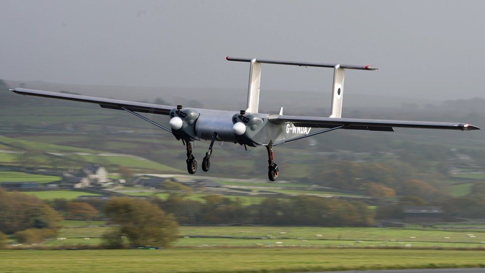
A team of scientists and engineers have traveled to Antarctica to test a drone that will assist in predicting the effects of climate change. This autonomous aircraft will map areas of the continent that have previously been inaccessible to researchers. Initial testing of the drone took place in harsh weather conditions around Wales' highest peaks. The first experiment will involve surveying the mountains beneath an ice sheet to determine the rate at which the ice may melt, contributing to global sea-level rise. The current technology limits scientists' understanding of Antarctica due to dangerous conditions such as strong winds, freezing temperatures, sudden storms, dark winters, and the logistical challenges of transporting pilots and fuel. The British Antarctic Survey has collaborated with UK company Windracers to develop this new drone, which can be easily repaired if any issues arise. It was tested in North Wales to simulate the challenging weather and terrain of Antarctica. The drone has the capability to fly to remote areas without risking the safety of pilots. It can transport up to 100kg of cargo over a distance of 1,000km. Equipped with radar and cameras, the drone collects data during its flights, which are monitored by an engineer from a computer. The drone will be operated from the Rothera base in Antarctica, but the hope is to eventually fly it from the UK. It is also more fuel-efficient than traditional planes, reducing the environmental impact of scientific research. The collected data will be processed at the British Antarctic Survey headquarters in Cambridge. Some of it will be used to update a model of Antarctica called BEDMAP2, which reveals the complex shape of the land beneath the ice. Large areas of Antarctica have yet to be mapped, and the drone's survey work aims to fill in these gaps. Understanding the topography of the continent is crucial because it affects the rate at which the ice will melt. If an ice sheet is exposed to warmer waters and encounters obstacles like mountains, its melting process will be impacted. In its first experiment, the drone will use radar to emit radio waves onto an ice sheet named Fuchs Piedmont. By listening for the reflections of these waves, the drone will be able to create a detailed image of the land. This information will contribute to more accurate predictions regarding global sea-level rise caused by melting ice sheets. The drone's capabilities also include surveys of marine life, such as krill, and environmentally sensitive areas. This innovative technology opens up exciting possibilities for scientific research in Antarctica.