-

-
-
Loading
Loading

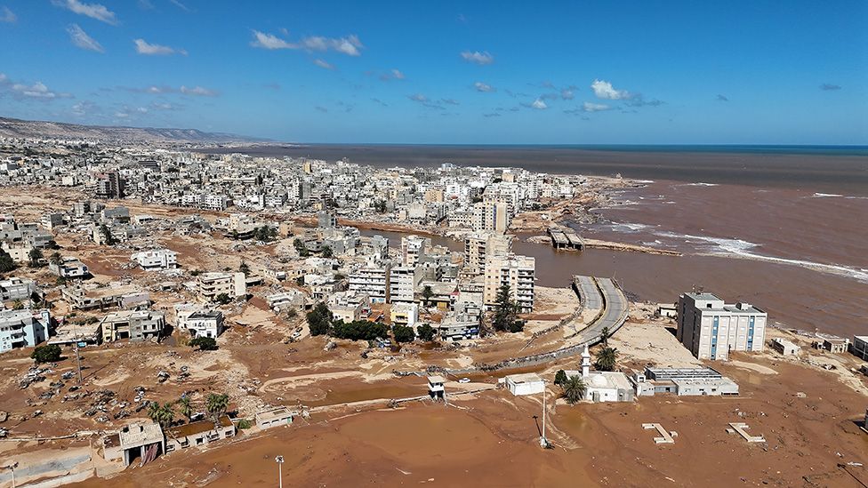
Satellite images reveal the extensive damage caused by floods in the Libyan port of Derna. The floods occurred after heavy rains brought by Storm Daniel caused two dams to burst on the usually dry Wadi Derna riverbed that runs through the city. The torrents of water and debris left a trail of devastation, sweeping away bridges, streets, and entire communities. The Wadi had several bridges connecting the port area with the western side of the city. These bridges, along with multiple residential and government buildings, were demolished by the powerful waters, which were described by one official as "like a tsunami." A major coastal road near the port was also washed away. According to reports, almost 96% of properties in the nearby Al-Eilwa neighborhood were flooded. The population of Derna was about 125,000 before the storm hit Libya. The city's mayor estimated that around 18,000 to 20,000 people may have died due to the number of completely destroyed neighborhoods. Numerous others were injured or missing, while many are left without homes. Analysis by the United Nations indicates that over 2,200 buildings were exposed to the rushing floodwaters, and at least six bridges, as well as the port area, were damaged. Each red dot in the satellite image represents a structure affected by the flooding. Neighborhoods severely impacted by the floods, including Al-Bilad and Al-Maghar on both sides of the river, were also home to healthcare facilities that served the entire city. Additionally, homes built on the sea side of the dam in the dry riverbed bore the brunt of the floodwaters. Community facilities, such as buildings around Darnes Football Club's home ground, were also destroyed or covered in layers of mud and debris.